I love chalk hills, and in particular the South Downs in Sussex, where I was born and raised. In truth, although the Downs were a magical but vaguely ominous background presence in my youth, I never actually walked on their ancient trackways until I was about 18 or 19. All my youthful explorations on foot, by bike and bus were in the central part of Sussex called the Weald (stretching east into Kent and west to the Hampshire border, but these boyhood explorations described a much smaller orbit). ‘Weald’ comes from Old English word meaning ‘forest’.
Before going too much further, a bit of geology needs be explained. Many millions of years ago, during the Jurassic and Cretaceous geological periods, the bit of the world that is now the South-East of England was under warm, shallow tropical seas. Huge rivers flowing into this sea deposited vast amounts of eroded sands, silts and muds in successive layers over the aeons, to create a sort of colossal club sandwich of sandstones, clays and limestones. The top slice of white bread is the chalk (in Lower, Middle and Upper layers), created out of the decomposed calcium skeletons of untold billions of microscopic algae that swarmed in these warm seas about 100-65 million years ago. By this time there was little deposition of other sediments, so these chalk strata are pretty much pure calcium carbonate, blinding white when exposed. Anyway, about 45 million years ago Africa and India were on their way back North and, not looking where they were going, collided with Europe and Asia, pushing up the Himalaya, the Alps and other mountain ranges of Eurasia as they did so. However, much more importantly, our club sandwich was also bent out of shape, being pushed up out of the sea into a huge elongated dome (which geologists call an anticline). The layers cracked (rock not generally being known for its flexibility) and over the following millions of years the highest parts of the misshapen sandwich eroded down from these fissures, eventually leaving the only the edges of the upper strata. This is why the landscape south of London follows a mirror-image pattern towards the English Channel; North Downs (chalk), clays, greensand ridge, more clays, a central high block of the oldest sandstone, yet more clays, a smaller greensand strip, even more clays and finally back to chalk again at the South Downs, where the strata curve down in a sincline under the Channel to rise again in Northern France. The Weald is the tumbled ruins of sandstone and clay between the cleanly sheared-off edges of the chalk strata. Viewed from directly overhead, imagine a huge eye; the skin of the eyelids representing the chalk ridges curving to join at the east and west ends, the white and iris the greensand and clays, the pupil the central hard sandstone of the High Weald.
Where the chalk is pure in geological make-up and in form, the Weald is chaotic; the multiplicity of underlying rock creates a distinctive, varied landscape of successive ridges and valleys, much still heavily wooded even today. Where the Downs offer smooth flowing ridges and uninterrupted vistas, the Weald is intimate with one valley being insulated from the next; constant change occurs around each corner and over every hill. The area is further divided into Low and High Wealds, which nomenclature is self-explanatory. I grew up in a place called Crowborough on the edge of Ashdown Forest, a former royal hunting ground halfway between London and the Channel coast, on the central high sandstone outcrop which forms the High Weald. From the highest point here I could see over the lesser southward rise of the greensand to the mighty South Downs, and, turning through 180 degrees, the line of the much higher northern greensand ridge with the North Downs behind; I would look up and wonder how high above me the chalk dome would have been 45 million years ago, before the endless years of erosion removed it to leave the northern and southern ridges as its only remnants. Even now, the outer slopes of the chalk (known as the dip) preserve the shallow angle of the sides of the original bowl and you can follow these angles in imagination to a convergence high above north Sussex. In contrast, the slopes of the chalk facing into the bowl (the scarp) are abrupt, almost perpendicular in parts, retaining the memory of how the rock was ruptured in geological upheaval.
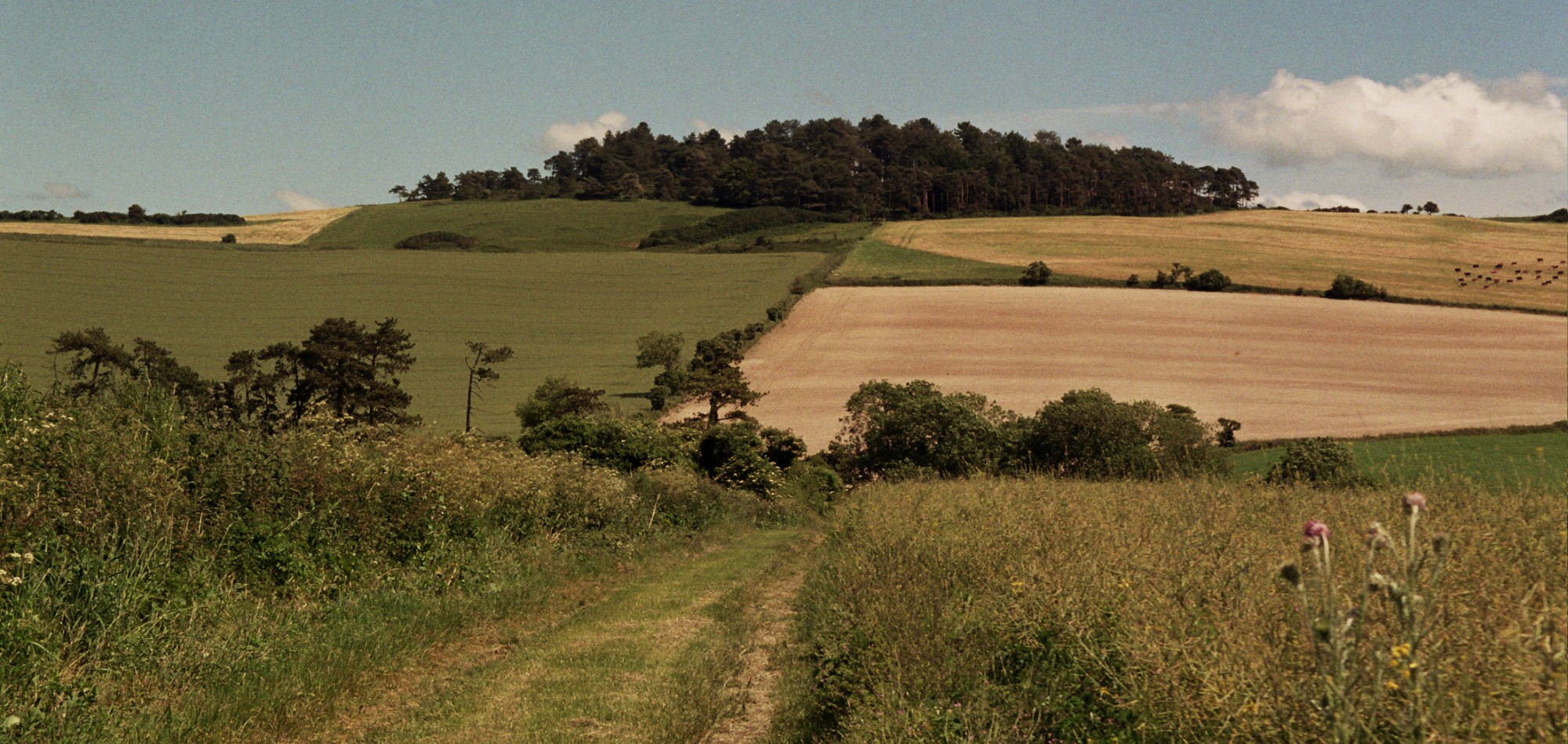
From the sandy, dry High Weald you drop by steep lanes, incised deeply into the stone through millennia of use, to the wetter, clayey Low Weald. This is an ancient area, rich with thousands of years of human use. The South Downs are also ancient, but their atmosphere is of civilisations gone to dust, the picked bones of a landscape, frozen and dessicated history; history in the Weald still lives, layered over millennia to create a sort of social geology where the story of how people lived can be easily read, and still has influence on how people live there today. These two areas, Downs and Weald, were the poles of my world, and both contain their own polarities; the Downs cleansing, uplifting, open yet enigmatic, the Weald enveloping, comforting, homely yet secretive. Visually, the South Downs are easily described; a green, smooth, flowing ridge, billowing like a heavy swell, an imperceptibly breaking wave ever threatening to engulf the fields and farms, towns and villages of inland Sussex. The Weald is much more complex and convoluted; hammer ponds in hushed shaded valleys, white-cowled oasts peeping over burnt-orange-tile-hung farmhouses, shingled church spires on distant ridges, greeny-grey fissured and sculpted sandstone outcrops, heather-glowing high heath, water-flowing subterranean ghylls. If you know Alfred Bestall’s illustrations in the Rupert Bear annuals you will have some idea of what large areas of the Weald look like; the landscapes in his illustrations were apparently based on the area in which he lived in North Wales, but the pictorial elements of dense woods, gentle hills and narrow valleys, successive waves of lush green foliage turning to purple with distance, the occasional church spire clearing the treetops, give a good approximation of this archetypal English landscape.
Many things that shaped the area are now memory; iron is no longer smelted as it was from at least Roman times until the Industrial Revolution, although deep in woods or incorporated into a garden as a huge water feature can be found hammer ponds, streams damned to provide water power for forge hammers. As a child on the bus to school in spring I would see men, balanced on high stilts, stringing the tall hop-poles ready for that summer’s crop, creating enormous cat’s cradles in the fields lining the road all the way to Eridge; much of the Low Weald in Kent was given over to hops until the sixties. Hop growing is hugely reduced nowadays, but the distinctive white-cowled, circular oasts where the flowers were dried, now mostly private homes, are bequeathed to today’s landscape as reminders. Riding my bike through the lanes around Crowborough, past Redgate Mill and up to Rotherfield on its eminence, or down the main Uckfield road, the radio masts towering to my right, to Herons Ghyll before diving down and steeply up again to Fairwarp, I slowly became aware of all the history soaked into the landscape around me. Ruined mills, breached pond bays, coppices grown wild through disuse, railway cuttings through which only ghost trains now passed, even bits of Roman road still with original ironstone-slag surfaces; all these could be found in bosky valleys and rioting woodlands, and I sought them out, inhaling deeply the atmosphere of all-returns-to-earth rot, deep greeny-brown and humus-perfumed. The smell of decay means life is recycling itself, taking on new forms, although I doubt I thought of it this way as a youth; I just loved the deliciously melancholic and abandoned feel of places like these.
In many ways, the Weald hasn’t suffered as badly from the ravages of modern life as some areas, hasn’t lost its soul completely; you can still, if you want to, explore the maze of lanes away from the main roads and find green peace. There are no motorways and few fast roads passing through, although the formerly serpentine A26 between my childhood home and school at Eridge has been straightened, a vandal’s knife slash through the old hop-fields and orchards, so that Mr Middle-Manager in his BMW or Audi can get to work in Tunbridge Wells without having to bother about slowing down; discarded to either side remain those interesting squiggly bits of road, tarmac oxbow lakes, silted with grass and gently returning to nature. If you like, accompany me on the Southern train from London Bridge to Uckfield which seems to retreat into the past as it heads southwards. After Oxted and the tunnel through the Greensand ridge you are in the Weald and the stations get smaller; Edenbridge is somewhere, Hever is on the way to somewhere else, Cowden is seemingly nowhere. We alight at Eridge (where once trains connected to take you all over Sussex and Kent before a certain Dr Beeching decided nobody needed a choice of transport; travel anywhere you like as long as it’s by car), have a pint at the Huntsman’s and then follow one of those squiggly bits I mentioned, up what used to be called Snake Hill, towards Eridge Forstal.
At the top, stand at the bus stop for a few minutes (ignoring for the moment BMW Man, HGV Man and Van Man hurtling past) and look southwards. Nothing out of the ordinary, but all the parts coalesce into a whole of stunning beauty; the hillside drops away in front of you, Hamsell Manor snug in the valley below, and the landscape gradually rises again, intricately detailed; woods, small fields, hedges, crinkle-crankle lanes, tile-hung farmhouses, swelling up towards the spire of St Denys at Rotherfield in the blue distance. I have to think myself deeply fortunate to have been intimately linked to this bit of landscape as a child; my primary school is two hundred yards or so up the lane opposite, and my friends (Steve Woodger and Robin Downes, Clive and Jimmy; wonder where you are now) lived in the village or on the country estates spread in front of us; their parents still worked at that time (the early sixties) mostly for the Abergavenny or Soames families at Eridge Park or Hamsell Manor, as gamekeepers, farm workers, domestic staff. I would sometimes venture back here at weekends and explore the estates, timidly, with Steve or Robin leading; fording streams, hanging off branches, hiding-and-seeking amidst hot, dry, dusty, hayfevery wheatfields.
Laying aside reverie, we can walk up the Forstal, noise diminishing away from the main road, past Eridge County Primary. My old school is now a private house; the family’s children have free rein amongst the former playground’s trees and rocks. Over Hamsell Wood Farm we can see further south and east towards Saxonbury Hill, folly tower breaking mysteriously out of the cloud bank of woods. Down now along lanes, then farm tracks to cross the railway and stream by Harrison’s Rocks, huge versions of the child-size sandstone outcrops in the old playground. Through the constantly changing interplay of elements (up and down, light and dark, water and rock, wood and field, lane and path) we can find our way west through Mott’s Mill to Friar’s Gate where we enter Ashdown Forest; steeply from here a road leads, past the house where Richard Jefferies lived for a while, to Crowborough. Turning southwards, and upwards, through the ancient coppice of Five Hundred Acre Wood (as 100 Aker Wood it appears in AA Milne’s Winnie-the-Pooh books; the author lived in Hartfield a couple of miles away) the track eventually bursts out on to high, open heathland, vast prospects opening out all around. We can now follow the Roman road through the heather and ling and gorse, navigating by the Scots pines huddling in clumps all over the Forest; we are aiming for Camp Hill Clump in its small Iron Age earthwork. It looks a long way, but it’s easy, fast, exhilarating walking over this high and dry heathland; in summer we will kick up dust and make the gorse crackle as we pass.
The radio masts at King’s Standing, another minatory presence from childhood (aircraft warning lights glowing red at night, hanging in the black), are gone now, but just down the road Duddleswell Tea Rooms still looks exactly as it did all those years ago; set back off the road behind a close-cut lawn, white-rendered, gravel path to the central door, symmetry in the black-framed bay windows either side. If this was a hushed, gently breezy, hazily sunny, warm Saturday afternoon in the late sixties we could sit and wait here, eyes half-closed against the light, for a number 119 bus back to Crowborough, but Southdown double-deckers haven’t run past here for many years, so we’ll walk south-easterly away from the road and down off the edge of the Forest. Up, down and around tortuous lanes we come to High Hurstwood; this tiny, scattered community could once summon enough people (housewives with shopping baskets, smartly-dressed pensioners going to meet their friends in Uckfield, teenagers with pocket money to spend in the record shop) to make a sizeable crowd waiting at The Maypole, and fill to capacity the big Leyland single-decker that ventured down the deeply-sunken lane three times a week.
We can complete the circle, on what’s become a sort of circumnavigation of a childhood, and walk on down to the railway viaduct by old mill ponds, then by lanes up and up through Burnt Oak and Stone Cross, each just a farm and a junction of old lanes with little Dairylea triangles of grass and those lovely Sussex road signs to show you the way to Crowborough. We enter the town past Alderbrook Estate (no prefabs now) and Luxford Cottage where my brother Michael used to live. We turn left down Blackness Road, past Luxford Manor; Michael’s father-in-law was the gardener there until the early seventies (prog rock fans may be interested to know that Van Der Graaf Generator recorded their 1971 album Pawn Hearts here). Turning right down wooded paths, then round the back of the old brickworks we emerge next to Crowborough station. This is actually in Jarvis Brook, a previously separate settlement in the valley equidistant between the town and Rotherfield (in fact the station when opened was named after Rotherfield, as this was then far more important than Crowborough, which only grew after the railway arrived). My first job after leaving school was here in a small print firm in a tiny building, Lexden Lodge, hard by the railway embankment; the start of adult life after an, in many ways, idyllic childhood.
When I started writing this I didn’t really have an idea where it was going to end up, but it turned from topography to autobiography. For me the two are very closely linked; it’s unthinkable to describe any part of my life without reference to the landscape it was lived in. A large part of me was constructed in these places; they made me what I am.
Maybe it’s time to go home.